The 7 most beautiful walks in Puy-de-Dôme
The Puy-de-Dôme is a popular destination for experienced hikers, and for good reason: sumptuous scenery, Auvergne volcanoes covered in a thick blanket of greenery, itineraries for all levels, and an incredible number of trails to choose from in this department that seems to have been created for hiking!
So, whether you decide to go hiking with friends, solo, as a family, or with your energetic furball, you’re bound to find a trail or trails to suit you in the Puy-de-Dôme. But be warned: you may fall in love with this region, with its wild and unusual landscapes…
Where to go hiking in the Puy-de-Dôme?
If you’re a fan of nature and mountain scenery, you won’t be disappointed in the Puy-de-Dôme. This green setting boasts numerous (dormant) volcanoes, natural regional parks and absolutely sublime mountain ranges. A puy is a dormant volcano. Here are 7 walks to do in the Puy-de-Dôme.
Hike no. 1: Puy Pariou from the Goules car park

- Duration: 2 hrs 25 mins
- Distance: 6.47 km
- Difference in altitude: 197 m
- High point: 1172 m
- Low point: 968 m
- Difficulty: moderate
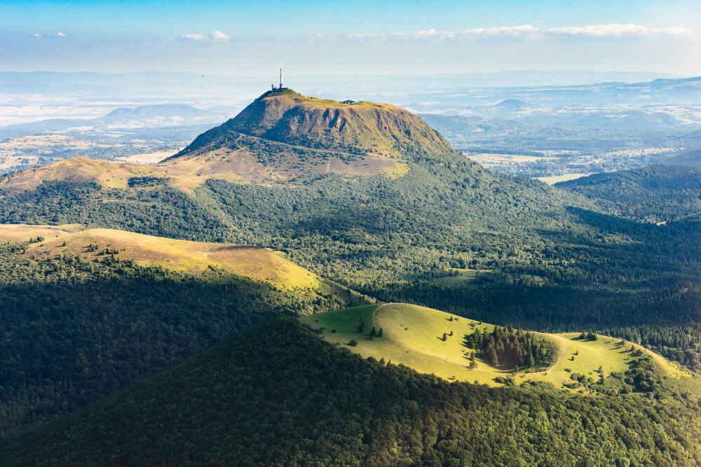
Start and finish at the Les Goules car park. As well as the view of the crater, the highlight of the route is the steps that take you directly into the crater floor. An ideal spot for an impromptu picnic or break. The Puy Pariou peaks at 1,200 metres, giving you the chance to see the other puys, including the Puy-de-Dôme, as well as the city of Clermont-Ferrand from its highest point.
Walk 2: the Adventif massif around Le Mont-Dore
- Duration: 7 h 00
- Distance: 15.72 km
- Difference in altitude: 887 m
- High point: 1716 m
- Low point: 1006 m
- Difficulty: medium
This hike may take you a whole day, but it will take you past 3 magnificent waterfalls and give you an exceptional view of the Sancy massif and the Chaîne des Puys. The first of these is the Queurueilh waterfall, with its 20-metre-high cascade, followed by the Rossignolet waterfall, which looks like a wedding veil the way it falls. The 3rd and final waterfall is the Grande Cascade du Mont-Dore, one of the highest in the Auvergne region. Access to this waterfall is forbidden in winter by municipal by-law.
Walk no. 3: The Chiloza waterfalls
- Duration: 1 hour 45 minutes
- Distance: 4.79 km
- Difference in altitude: 140 m
- High point: 992 m
- Low point: 848 m
- Difficulty: moderate
A walk sheltered from the heat thanks to the undergrowth and the Couze Pavin, which forms small waterfalls on either side of the bank. Access is from the road to the right of the Bois de Gravière campsite in Besse-en-Chandesse. This route requires good walking shoes, as it is fairly uneven in places. Although normally considered easy, it is not recommended for families with small children or pushchairs.
Walk no. 4: in the footsteps of the Druids
- Duration: 2 hrs 05 mins
- Distance: 5.27 km
- Difference in altitude: 211 m
- High point: 701 m
- Low point: 510 m
- Difficulty: medium
Boulders stacked one on top of the other in the middle of the woods, remains of water mills, a cup stone linked to ancient rites, a megalithic monument made up of menhirs arranged in a Bronze Age circle, the ruins of an ancient medieval fortress… Here’s what you can see if you follow the Chemin des Druides. The trail starts from the Fayet-le-Château town hall car park. This nature walk takes you through meadows, forests, streams and surprising places that are thought to be linked to the Druid gatherings that once took place in the region. Also worth a visit is the pond at “La Gravière”.
Walk 5: Montbert Forest and Lac Chauvet

- Time: 2 hrs 25 mins
- Distance: 7.17 km
- Difference in altitude: 117 m
- High point: 1257 m
- Low point: 1162 m
- Difficulty: easy
A walk for all the family, with undergrowth, beech and spruce forests, fields in bloom in spring, and a picnic or snack on the banks of Lac Chauvet. Views of the Monts Dore, the Cantal and the lake. Beware of mud in wet weather, so bring good shoes if necessary. You may come across herds of cattle on this section of the walk.
Hiking route 6: The Grottes de Rajat and the Cirque du Marais
- – Duration: 4 hrs 40 mins
- – Distance: 12.19 km
- – Difference in altitude: 409 m
- – High point: 1,086 m
- – Low point: 863 m
- – Difficulty: moderate
There are plenty of sites to discover on this hike: the Grottes de Rajat, the Château de Murol, the Cirque and the Dent du Marais, and the villages of Chautignat and Beaune-le-Froid. The Grottes de Rajat, in the cliff above the village, were once inhabited troglodyte houses, probably dating back to the Gallic period or even earlier. On this walk, you’ll enjoy views of the medieval Château de Murol and the Sancy massif. At the top of the cliff, you can admire the Lac de Chambon and the Vallée de Chaudefour. The Dent du Marais is a 100m-high needle above the lake. Nearby, on the way to the caves, you’ll discover the old St-Nectaire cheese maturing caves, some of which are still in operation. If you like Saint-Nectaire cheese, it would be a real shame not to do this little loop and take home a unique souvenir.
The GR30, discovering the Volcanoes and Lakes of Auvergne
This GR winds its way around the Auvergne puys for almost 189 km from the foot of the Puy de Sancy. It takes no less than 9 days to complete the hike, which is of medium difficulty. A tour of the puys and mountain lakes, extraordinary viewpoints, typical villages… Everything is calculated to help you discover the most beautiful panoramas in the Puy-de-Dôme.
200 audioguided tours for cities all around the world
Download