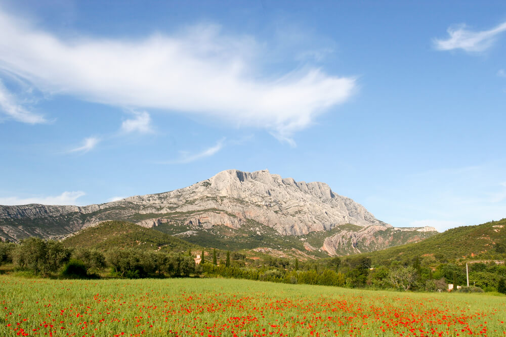
Montagne Sainte-Victoire: walks, activities and visits
Follow in the footsteps of Cézanne, who had a special affection for Mont Sainte-Victoire. The French painter produced no fewer than 87 paintings on this mountain of elegant curves and changing colours…
He said of it: “I need to know the geology, how Sainte-Victoire takes root, the geological colour of the land, all that moves me, makes me better”, and he painted Mont Sainte-Victoire for the rest of his life.
The Cross of Provence is also inseparable from the massif, and can be seen from miles around. Mont Sainte-Victoire offers a wide range of activities, including walks, religious and architectural heritage, typical Provencal landscapes, a variety of sporting activities and family picnics. Like Mont Ventoux, the Sainte Victoire site is a must-see when visiting Provence.
How do you visit Mont Sainte-Victoire?
To discover all the facets of Mont Sainte-Victoire, we recommend that you take the road around it. To the south, you can admire the sharp cliffs that rise above the Arc basin. To the north, the relief softens on the plateaux below the mountain. Mont Sainte Victoire covers no less than 32,000 hectares of land that is part of the Natura 2000 network.

Montagne Sainte-Victoire is not open to visitors all year round. Following the terrible fire in 1995, access is restricted in summer to protect the natural heritage. So it’s important to find out before you go, for example at the tourist office in Aix-en-Provence, which will give you directions.
There are a number of hiking trails and rock-climbing opportunities. 18 kilometres long and 5 kilometres wide, Mont Sainte-Victoire is located in both Bouches-du-Rhône and Var, in south-eastern France. Its highest point is 1,011 metres above sea level.
It is also possible to sleep at the Saint Victoire priory most of the time, provided there is room, as reservations are not possible. 14 beds are available in the refuge. The refuge is located on the east side of the esplanade. This former monastery is run by an association.
How do I get to Mont Sainte-Victoire?
On leaving Aix-en-Provence, take the D10 towards Vauvenargues for 7 kilometres, then turn right towards the Bimont dam as far as the car park of the same name.
What kind of hike is there on Sainte-Victoire?
First of all, you need to know that hiking around Sainte-Victoire is well worth the effort!
It’s a 600-metre climb, with some steep sections depending on the route you choose, so you’ll need a minimum of equipment: hiking boots, warm winter clothes and/or rain gear, a hat, food and drink.
Please note: there are no drinking water points on the massif, so plan your water requirements according to the number of people taking part in the hike before setting off into this arid wilderness.
Medium-level trail from the Plan d’En Chois car park
- Departure and return from the Plan d’En Chois car park
- Duration: 4 hours each way to the Croix de Provence and back
- Difference in altitude: 650 metres
- Difficulty: moderate
Take the path that leads to the Cézanne refuge, a wide path with a view of the Croix de Provence, ideal for a warm-up. Arrive at the hamlet of Le Trou, where you can see the refuge and a wrought-iron cross.
Climb up to the Prieuré with a nice change in altitude, then take the “easy” path via the Pas de l’Escalette, which takes you up to 1? hours. From the Pas de l’Escalette, you’ll have a lovely view of the Etang de Berre, Gardanne, the Sainte-Baume mountain range and Lake Bimont… A 180° view.
When you reach the Priory, you’ll discover this 17th-century building restored by the Association “Les Amis de Sainte-Victoire”, which continues to maintain it to this day.

After another 10-minute walk, you’ll come to the Croix de Provence, from where you’ll have a breathtaking view of the Priory below and the whole region.
Signposted footpaths on the western side of the mountain
- GR9 sentier des Venturiers: Les Cabassols – Prieuré (no. 20)
- GR9 les crêtes : Prieuré – Croix de Provence – Pic des Mouches (n°12)
- Imoucha blue route: Bimont – Prieuré (n°5)
- Red route: Plan d’En Chois – Prieuré (n°6)
- Yellow line: refuge Cézanne – Bau Cézanne (n°7), temporarily prohibited, dangerous
- Brown line: Cézanne refuge – Saint-Ser chapel (no. 10)
- Green Forcioli trail: Plan d’En Chois – le Garagaï (no. 8)
- Black route: les Deux Aiguilles – le Garagaï (n°9)
- Green route: Marbrière – Brèche du Clapier – crêtes (n°13)
- Christian de Barbarin path: Vauvenargues – Les Bonfillons
- Sentier jaune de l’Oppidum: les Deux Aiguilles – Oppidum (n°11)
- Sentier jaune du Trou: Le Bouquet – Saint Antonin

Waymarked paths on the eastern side of the mountain
- Sentier des Plaideurs: Vauvenargues – Col de Suberoque (n°19)
- Red path: Saut du Loup – refuge Baudino (n°14)
- Black route: chapelle Saint-Ser – col de Vauvenargues (n°15) closed from 1 February to 15 August 2022.
- Red route: Saint-Ser relay – Saint-Ser pass (no. 16)
- Green route: relais de Saint-Ser – Pic des Mouches (n°17)
- Bramefant green trail
- Brown route: Puyloubier – Pic des Mouches (closed path)
- GR9: Puyloubier – Pic des Mouches (n°12)
- Red route: Col des Portes – Pic des Mouches (n°18)
Where can I park to get to Sainte-Victoire?
Aurigon car park
You reach the Roques-Hautes car park via the D17 between Le Tholonet and Saint-Antonin de Bayon.
En Chois car park
Head towards Le Tholonet and follow the D17 to the car park before Le Bouquet.
Deux Aiguilles car park
Free parking at Saint-Antonin-sur-Bayon near the Maison de la Sainte-Victoire on the D17 between Le Tholonet and Saint-Antonin de Bayon. Ideal parking for those heading off to the climbing sites.
What activities are available at Montagne Sainte-Victoire?
The activities available at Montagne Sainte-Victoire are mainly sports-related:
- La Maison Sainte-Victoire: a museum and exhibition room, where visitors can learn about the fragility of the environment.
- Easy to difficult hikes, some of which involve climbing.
- Escalade aux Deux Aiguilles offers a total of more than 500 climbing routes, with a wide choice of grades, from rises to 300-metre long routes.
- Mountain biking is practised on 150 km of itineraries, about 12 circuits on several levels: easy to perilous.
- Tour of the Bimont dam.
- Visit the Bibémus quarry on the road to Vauvenargues. This site offers a magnificent view of Saint-Victoire, which inspired the painter Cézanne. The guided tour includes Cézanne’s cottage, reproductions engraved in enamelled stone, and the quarrying of the stones that were used from Antiquity to the 18th century to build the monuments of Aix-en-Provence. No self-guided tours.
- Paragliding: two-seater flights and sites for experienced and independent pilots. Two FFVL-approved sites: from the Saint-Ser car park (Puyloubier) to the Pic des Mouches, and to the south-west from the Pont de l’Anchois car park (Saint-Antonin sur Bayon).
- Château Gassier, at the foot of the Sainte-Victoire, 40 hectares of Côtes de Provence Sainte-Victoire vineyards, treasure hunts, picnics in the countryside with the vines as your backdrop, and wine workshops are all on offer at Château Gassier.
- Parc Animalier de la Sainte Victoire, an educational farm and leisure park with inflatable structures.
- Donkey or horse rides to discover the plains and landscapes of Provence.
- The 800-hectare Parc Départemental de Roques-Hautes offers hiking trails, a 25-hectare almond orchard, views of fig and olive trees…
- Pourrières, its heritage, remains and monuments.
- The restanques and bories, dry stone constructions typical of the Mediterranean basin in the middle of the garrigues.
Why is the mountain called Saint-Victoire?
Victoire comes from the Celtic or Ligurian word Ventur or Venturius, meaning God of the heights, as the site was occupied by Celtic-Ligurian tribes who built an oppidum (fortified prehistoric settlement) at the foot of the cliffs.
Why is there a cross at the summit of Mont Sainte-Victoire?
Abbé Meissonnier ordered its construction in 1871, to thank God for protecting Provence from the Prussian plague. The 22,000 donors who contributed to its construction have their names carefully preserved in a copper heart inside the monument. The Provence cross is 7 m high and stands on an 11 m high plinth. It can be seen from almost anywhere in the Bouches-du-Rhône département.
Practical information
- There are no drinking water points on Mont Sainte-Victoire for hikers,
- Toilets are available for those staying at the refuge.
- There are group refuges and gîtes scattered around for those wishing to hike for several days.
- Make sure you have the right equipment for the time of year and the type of walk (ridge, cliffs).
- The routes are graded by level, so it’s important to check before setting off on your adventure, especially if you’re not used to walking for several hours in the blazing sun!
- Don’t forget to check the weather forecast.
- Don’t stray off the marked paths, as it’s very easy to get lost, and the site is listed and protected.
- Bring a bag for your rubbish, as there is no rubbish collection on the mountain.
- For obvious reasons, it is forbidden to light fires or smoke on the site. These are simple rules that everyone can follow to ensure you have a good time and enjoy the panorama.
Sainte-Victoire has a rich prehistoric and Roman heritage, as well as numerous places of worship: the Hermitage of Saint Ser, the Priory of Sainte Victoire, the chapels of Notre-Dame d’Astorg and Sainte-Consorce, the Malivert oratory and the Provence cross. A rich Provencal architectural heritage, with numerous castles and picturesque villages. The Sainte-Victoire site boasts no fewer than 137 archaeological sites and 145 historical sites, and is also a link between the Var and Bouches du Rhône departments in the Provence region.
The legend of the Chapel of Saint Ser
It is said that in the 5th century, a hermit known as SERVUS DEI (Servant of God) took refuge in a cave on the south face of Sainte-Victoire, not far from the village of Puyloubier. The local Christians paid homage to her, which angered the Visigoth king, Euric, who demanded that her ears be cut off before she was beheaded. Her body was buried on the same spot. The pilgrimage that used to take place every year on Whit Monday to commemorate her martyrdom and the memory of her talent for curing deafness had to stop in 1993, after the chapel collapsed following a landslide caused by the fire of 1989, which ravaged a large part of the Sainte-Victoire landscape. The chapel was rebuilt in 2001 and, in honour of Saint Ser, features an altar, a spring and the ears of those involved in its reconstruction drawn on the wooden framework. It’s just one more little curiosity to discover!
200 audioguided tours for cities all around the world
Download